


CAP LABAUME

ramsay
User
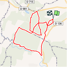

Length
10.6 km

Max alt
171 m

Uphill gradient
143 m
Km-Effort
12.5 km

Min alt
109 m

Downhill gradient
141 m
Boucle
Yes
Creation date :
2019-01-15 18:24:06.914
Updated on :
2019-01-15 18:24:06.914
1h00
Difficulty : Easy

FREE GPS app for hiking
 SityTrail
IGN / Geographical institutes
SityTrail Plus
The world is yours!
About
Trail Running of 10.6 km to be discovered at Occitania, Gard, Serviers-et-Labaume. This trail is proposed by ramsay.
Positioning
Country:
France
Region :
Occitania
Department/Province :
Gard
Municipality :
Serviers-et-Labaume
Location:
Unknown
Start:(Dec)
Start:(UTM)
607365 ; 4876484 (31T) N.
Comments