


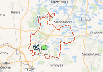
Mionnay-39km-296m

ThierryJ01
User

Length
39 km

Max alt
310 m

Uphill gradient
294 m
Km-Effort
43 km

Min alt
266 m

Downhill gradient
297 m
Boucle
Yes
Creation date :
2019-01-15 18:29:30.623
Updated on :
2020-10-09 20:17:41.947
2h53
Difficulty : Easy

FREE GPS app for hiking
 SityTrail
IGN / Geographical institutes
SityTrail Plus
The world is yours!
About
Trail Mountain bike of 39 km to be discovered at Auvergne-Rhône-Alpes, Ain, Mionnay. This trail is proposed by ThierryJ01.
Positioning
Country:
France
Region :
Auvergne-Rhône-Alpes
Department/Province :
Ain
Municipality :
Mionnay
Location:
Unknown
Start:(Dec)
Start:(UTM)
649707 ; 5084245 (31T) N.
Comments