


20181106-st aubin epinay

doudet
User
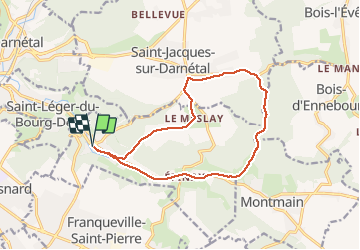

Length
13.1 km

Max alt
160 m

Uphill gradient
159 m
Km-Effort
15.2 km

Min alt
43 m

Downhill gradient
159 m
Boucle
Yes
Creation date :
2019-01-15 18:31:16.8
Updated on :
2019-01-15 18:31:16.8
3h19
Difficulty : Medium

FREE GPS app for hiking
 SityTrail
IGN / Geographical institutes
SityTrail Plus
The world is yours!
About
Trail Walking of 13.1 km to be discovered at Normandy, Seine-Maritime, Saint-Aubin-Épinay. This trail is proposed by doudet.
Positioning
Country:
France
Region :
Normandy
Department/Province :
Seine-Maritime
Municipality :
Saint-Aubin-Épinay
Location:
Unknown
Start:(Dec)
Start:(UTM)
367857 ; 5475928 (31U) N.
Comments