


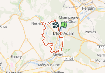
ALENTOURS DU CONFLUENT DU SAUSSERON ET DE L'OISE

NUITEVEN
User

Length
22 km

Max alt
113 m

Uphill gradient
323 m
Km-Effort
26 km

Min alt
22 m

Downhill gradient
322 m
Boucle
Yes
Creation date :
2019-01-15 18:37:06.012
Updated on :
2020-01-18 16:21:19.13
5h45
Difficulty : Unknown

FREE GPS app for hiking
 SityTrail
IGN / Geographical institutes
SityTrail Plus
The world is yours!
About
Trail Walking of 22 km to be discovered at Ile-de-France, Val-d'Oise, Parmain. This trail is proposed by NUITEVEN.
Positioning
Country:
France
Region :
Ile-de-France
Department/Province :
Val-d'Oise
Municipality :
Parmain
Location:
Unknown
Start:(Dec)
Start:(UTM)
442325 ; 5440538 (31U) N.
Comments