


FFMP

ochelen
User
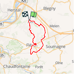

Length
19.6 km

Max alt
273 m

Uphill gradient
279 m
Km-Effort
23 km

Min alt
161 m

Downhill gradient
283 m
Boucle
Yes
Creation date :
2019-01-15 18:39:01.941
Updated on :
2019-01-15 18:39:01.941
4h03
Difficulty : Easy

FREE GPS app for hiking
 SityTrail
IGN / Geographical institutes
SityTrail Plus
The world is yours!
About
Trail Walking of 19.6 km to be discovered at Wallonia, Liège, Blegny. This trail is proposed by ochelen.
Description
balade urbanisée et chemin bucolique
Positioning
Country:
Belgium
Region :
Wallonia
Department/Province :
Liège
Municipality :
Blegny
Location:
Saive
Start:(Dec)
Start:(UTM)
689254 ; 5614707 (31U) N.
Comments