


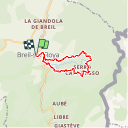
Circuit de Carleva

domi06
User

Length
11.4 km

Max alt
887 m

Uphill gradient
802 m
Km-Effort
22 km

Min alt
278 m

Downhill gradient
803 m
Boucle
Yes
Creation date :
2019-01-14 17:30:19.746
Updated on :
2019-01-14 17:30:19.746
4h25
Difficulty : Medium

FREE GPS app for hiking
 SityTrail
IGN / Geographical institutes
SityTrail Plus
The world is yours!
About
Trail Walking of 11.4 km to be discovered at Provence-Alpes-Côte d'Azur, Maritime Alps, Breil-sur-Roya. This trail is proposed by domi06.
Description
Départ pont inférieur du lac de Breil:B1,longer les fortifications B3,Oratoire B105,prendre à gauche-Serre de Pozzo,Cabanasso.B107-B104
Positioning
Country:
France
Region :
Provence-Alpes-Côte d'Azur
Department/Province :
Maritime Alps
Municipality :
Breil-sur-Roya
Location:
Unknown
Start:(Dec)
Start:(UTM)
380723 ; 4865864 (32T) N.
Comments