


Tête de SIRUOL

trailer.nono
User

Length
15.3 km

Max alt
2034 m

Uphill gradient
1454 m
Km-Effort
35 km

Min alt
644 m

Downhill gradient
1453 m
Boucle
Yes
Creation date :
2019-01-15 18:59:40.404
Updated on :
2019-01-15 18:59:40.404
5h01
Difficulty : Medium

FREE GPS app for hiking
 SityTrail
IGN / Geographical institutes
SityTrail Plus
The world is yours!
About
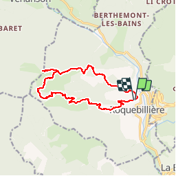
Trail Walking of 15.3 km to be discovered at Provence-Alpes-Côte d'Azur, Maritime Alps, Roquebillière. This trail is proposed by trailer.nono.
Positioning
Country:
France
Region :
Provence-Alpes-Côte d'Azur
Department/Province :
Maritime Alps
Municipality :
Roquebillière
Location:
Unknown
Start:(Dec)
Start:(UTM)
364265 ; 4875077 (32T) N.
Comments