


bomal 16.8kms

ochelen
User
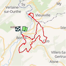

Length
16.8 km

Max alt
286 m

Uphill gradient
501 m
Km-Effort
24 km

Min alt
131 m

Downhill gradient
501 m
Boucle
Yes
Creation date :
2019-01-15 19:01:42.991
Updated on :
2019-01-15 19:01:42.991
4h46
Difficulty : Unknown

FREE GPS app for hiking
 SityTrail
IGN / Geographical institutes
SityTrail Plus
The world is yours!
About
Trail Walking of 16.8 km to be discovered at Wallonia, Luxembourg, Durbuy. This trail is proposed by ochelen.
Points of interest


Positioning
Country:
Belgium
Region :
Wallonia
Department/Province :
Luxembourg
Municipality :
Durbuy
Location:
Bomal
Start:(Dec)
Start:(UTM)
679331 ; 5583786 (31U) N.
Comments