


Oingt 4.1 km

GOELERANDO2
User
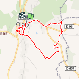

Length
4.1 km

Max alt
566 m

Uphill gradient
158 m
Km-Effort
6.2 km

Min alt
429 m

Downhill gradient
159 m
Boucle
Yes
Creation date :
2019-01-15 19:02:03.93
Updated on :
2019-01-15 19:02:03.93
1h04
Difficulty : Easy

FREE GPS app for hiking
 SityTrail
IGN / Geographical institutes
SityTrail Plus
The world is yours!
About
Trail Walking of 4.1 km to be discovered at Auvergne-Rhône-Alpes, Rhône, Val d'Oingt. This trail is proposed by GOELERANDO2.
Description
Départ du parking aux Cars
Positioning
Country:
France
Region :
Auvergne-Rhône-Alpes
Department/Province :
Rhône
Municipality :
Val d'Oingt
Location:
Oingt
Start:(Dec)
Start:(UTM)
622755 ; 5089598 (31T) N.
Comments