


2018 11 EVRY T1

michel1025
User
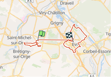

Length
33 km

Max alt
98 m

Uphill gradient
281 m
Km-Effort
37 km

Min alt
26 m

Downhill gradient
279 m
Boucle
No
Creation date :
2019-01-15 19:02:45.617
Updated on :
2019-01-15 19:02:45.617
5h20
Difficulty : Unknown

FREE GPS app for hiking
 SityTrail
IGN / Geographical institutes
SityTrail Plus
The world is yours!
About
Trail Walking of 33 km to be discovered at Ile-de-France, Essonne, Sainte-Geneviève-des-Bois. This trail is proposed by michel1025.
Description
EVRY T1
Positioning
Country:
France
Region :
Ile-de-France
Department/Province :
Essonne
Municipality :
Sainte-Geneviève-des-Bois
Location:
Unknown
Start:(Dec)
Start:(UTM)
451667 ; 5386507 (31U) N.
Comments