


FOSSES - LUZARCHES

NUITEVEN
User
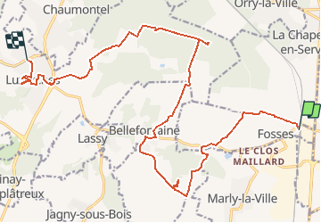

Length
21 km

Max alt
138 m

Uphill gradient
282 m
Km-Effort
25 km

Min alt
44 m

Downhill gradient
330 m
Boucle
No
Creation date :
2019-01-15 19:25:40.908
Updated on :
2020-01-18 16:23:21.515
5h23
Difficulty : Unknown

FREE GPS app for hiking
 SityTrail
IGN / Geographical institutes
SityTrail Plus
The world is yours!
About
Trail Walking of 21 km to be discovered at Ile-de-France, Val-d'Oise, Fosses. This trail is proposed by NUITEVEN.
Positioning
Country:
France
Region :
Ile-de-France
Department/Province :
Val-d'Oise
Municipality :
Fosses
Location:
Unknown
Start:(Dec)
Start:(UTM)
465333 ; 5438640 (31U) N.
Comments