Trail Walking Gouy - Le berceau de l'Escaut - Photo

Le berceau de l'Escaut

 tracegps
tracegps

User

© OpenStreetMap contributors
Length
Length
11.8 km
Max alt
Max alt
128 m
Uphill gradient
Uphill gradient
127 m
Km-Effort
Km-Effort  
13.5 km
Min alt
Min alt
90 m
Downhill gradient
Downhill gradient
126 m
Boucle
Boucle
Yes
Creation date :
2014-12-10 00:00:00.0
Updated on :
2014-12-10 00:00:00.0

(1 Reviews)

Walking
Walking
3h15
Difficulty : Medium

Scan this QR Code to open this trail in the SityTrail application

FREE GPS app for hiking

Logo SityTrail SityTrail

IGN / Geographical institutes

Download SityTrail from the App Store Download SityTrail from Google Play

Logo SityTrail SityTrail Plus

The world is yours!

Download SityTrail from the App Store Download SityTrail from Google Play Download SityTrail on Huawei AppGallery

About

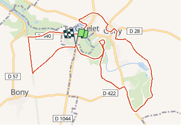
Trail Walking of 11.8 km to be discovered at Hauts-de-France, Aisne, Gouy. This trail is proposed by tracegps.

Description

Un beau circuit au départ du fort du Catelet (voir aussi l'atelier de broderie) pour découvrir l'Escaut naissant et l'ancienne abbaye du Mont-Saint-Martin. La variante remonte à la jonction de la rivière avec le canal de Saint-Quentin et revient par le cimetière américain et la ferme-auberge de Bony. Toutes les infos sont ICI

Elevation profile

Photos

Positioning

Country:
France
Region :
Hauts-de-France
Department/Province :
Aisne
Municipality :
Gouy
Location:
Unknown
Start:(UTM)
517416 ; 5538588 (31U) N.

Comments

Please log in to post a review or rate the element


Close
My subscriptions