


ferriere 13,6kms

ochelen
User
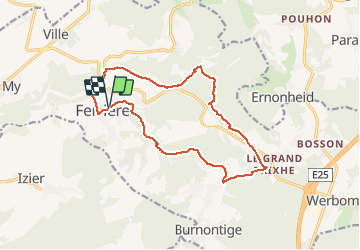

Length
13.7 km

Max alt
402 m

Uphill gradient
314 m
Km-Effort
17.9 km

Min alt
190 m

Downhill gradient
312 m
Boucle
Yes
Creation date :
2019-01-15 19:55:35.86
Updated on :
2019-01-15 19:55:35.86
3h08
Difficulty : Easy

FREE GPS app for hiking
 SityTrail
IGN / Geographical institutes
SityTrail Plus
The world is yours!
About
Trail Walking of 13.7 km to be discovered at Wallonia, Liège, Ferrières. This trail is proposed by ochelen.
Description
marché a travers bois et campagne
Positioning
Country:
Belgium
Region :
Wallonia
Department/Province :
Liège
Municipality :
Ferrières
Location:
Ferrières
Start:(Dec)
Start:(UTM)
685226 ; 5586370 (31U) N.
Comments