


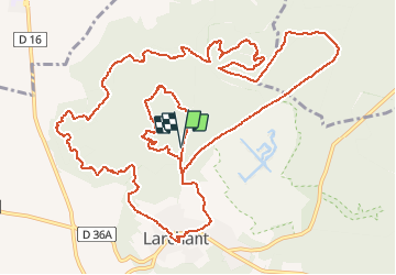
Larchant

gdela
User

Length
16.6 km

Max alt
120 m

Uphill gradient
254 m
Km-Effort
20 km

Min alt
63 m

Downhill gradient
253 m
Boucle
Yes
Creation date :
2019-01-15 19:56:13.854
Updated on :
2019-01-15 19:56:13.854
4h20
Difficulty : Difficult

FREE GPS app for hiking
 SityTrail
IGN / Geographical institutes
SityTrail Plus
The world is yours!
About
Trail Walking of 16.6 km to be discovered at Ile-de-France, Seine-et-Marne, Larchant. This trail is proposed by gdela.
Positioning
Country:
France
Region :
Ile-de-France
Department/Province :
Seine-et-Marne
Municipality :
Larchant
Location:
Unknown
Start:(Dec)
Start:(UTM)
470115 ; 5349054 (31U) N.
Comments
Bien les odeurs, le décor, le ciel bleu tout y était je vais la réédité avec des photos et un lien sur l'originale Merci pour la balade