


BEYNES ET LA VALLEE DE LA MAULDRE

NUITEVEN
User
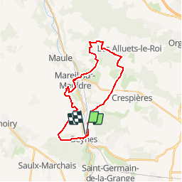

Length
24 km

Max alt
189 m

Uphill gradient
406 m
Km-Effort
29 km

Min alt
38 m

Downhill gradient
406 m
Boucle
Yes
Creation date :
2019-01-15 20:07:39.198
Updated on :
2019-04-29 08:35:05.035
6h28
Difficulty : Unknown

FREE GPS app for hiking
 SityTrail
IGN / Geographical institutes
SityTrail Plus
The world is yours!
About
Trail Walking of 24 km to be discovered at Ile-de-France, Yvelines, Beynes. This trail is proposed by NUITEVEN.
Positioning
Country:
France
Region :
Ile-de-France
Department/Province :
Yvelines
Municipality :
Beynes
Location:
Unknown
Start:(Dec)
Start:(UTM)
417524 ; 5412426 (31U) N.
Comments