


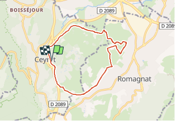
le tour de montrognon

jeanic63
User

Length
7.3 km

Max alt
577 m

Uphill gradient
175 m
Km-Effort
9.7 km

Min alt
457 m

Downhill gradient
176 m
Boucle
Yes
Creation date :
2019-01-15 20:10:41.867
Updated on :
2024-04-11 18:47:30.102
2h42
Difficulty : Unknown

FREE GPS app for hiking
 SityTrail
IGN / Geographical institutes
SityTrail Plus
The world is yours!
About
Trail Other activity of 7.3 km to be discovered at Auvergne-Rhône-Alpes, Puy-de-Dôme, Ceyrat. This trail is proposed by jeanic63.
Description
départ cimetière de ceyrat puy de dôme 63
Positioning
Country:
France
Region :
Auvergne-Rhône-Alpes
Department/Province :
Puy-de-Dôme
Municipality :
Ceyrat
Location:
Unknown
Start:(Dec)
Start:(UTM)
505393 ; 5064335 (31T) N.
Comments