


Pic Rébéquier Pont de L'Endre Var 3544 OT

verotrail
User
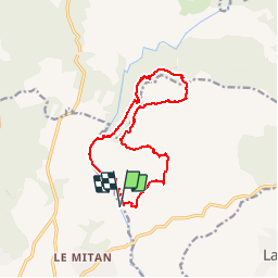

Length
14.1 km

Max alt
404 m

Uphill gradient
426 m
Km-Effort
19.8 km

Min alt
35 m

Downhill gradient
426 m
Boucle
Yes
Creation date :
2019-01-15 20:14:18.999
Updated on :
2019-01-15 20:14:18.999
4h10
Difficulty : Medium

FREE GPS app for hiking
 SityTrail
IGN / Geographical institutes
SityTrail Plus
The world is yours!
About
Trail Walking of 14.1 km to be discovered at Provence-Alpes-Côte d'Azur, Var, Le Muy. This trail is proposed by verotrail.
Positioning
Country:
France
Region :
Provence-Alpes-Côte d'Azur
Department/Province :
Var
Municipality :
Le Muy
Location:
Unknown
Start:(Dec)
Start:(UTM)
304966 ; 4820527 (32T) N.
Comments