


la napoule

phiphidechagny
User
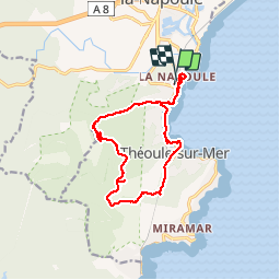

Length
14.8 km

Max alt
280 m

Uphill gradient
356 m
Km-Effort
19.5 km

Min alt
0 m

Downhill gradient
360 m
Boucle
Yes
Creation date :
2019-01-16 10:49:51.545
Updated on :
2019-01-16 10:49:51.545
5h53
Difficulty : Easy

FREE GPS app for hiking
 SityTrail
IGN / Geographical institutes
SityTrail Plus
The world is yours!
About
Trail Walking of 14.8 km to be discovered at Provence-Alpes-Côte d'Azur, Maritime Alps, Mandelieu-la-Napoule. This trail is proposed by phiphidechagny.
Description
Magnifique
Photos


Positioning
Country:
France
Region :
Provence-Alpes-Côte d'Azur
Department/Province :
Maritime Alps
Municipality :
Mandelieu-la-Napoule
Location:
Unknown
Start:(Dec)
Start:(UTM)
333506 ; 4820815 (32T) N.
Comments