Trail Walking Couflens - Les cabanes de Saubé, Cruzous et Bonrepos - Photo

Les cabanes de Saubé, Cruzous et Bonrepos

 tracegps
tracegps

User

© OpenStreetMap contributors
Length
Length
13.5 km
Max alt
Max alt
2191 m
Uphill gradient
Uphill gradient
1331 m
Km-Effort
Km-Effort  
32 km
Min alt
Min alt
928 m
Downhill gradient
Downhill gradient
1634 m
Boucle
Boucle
No
Creation date :
2014-12-10 00:00:00.0
Updated on :
2014-12-10 00:00:00.0

(0 Reviews)

Walking
Walking
5h00
Difficulty : Difficult

Scan this QR Code to open this trail in the SityTrail application

FREE GPS app for hiking

Logo SityTrail SityTrail

IGN / Geographical institutes

Download SityTrail from the App Store Download SityTrail from Google Play

Logo SityTrail SityTrail World

The world is yours!

Download SityTrail from the App Store Download SityTrail from Google Play Download SityTrail on Huawei AppGallery

About

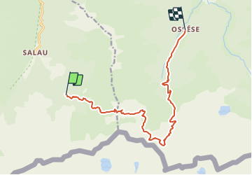
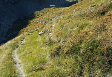
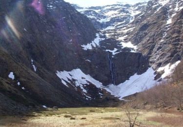
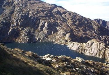
Trail Walking of 13.5 km to be discovered at Occitania, Ariège, Couflens. This trail is proposed by tracegps.

Description

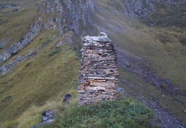
Grand comme trois fois la ville de Paris, le Haut-Couserans se situe au coeur des Pyrénées Ariègeoises à 1h30 de Toulouse. Son environnement naturel et bâtit exceptionnellement préservé, variant de 463m à 2865m, est à découvrir. Les cabanes de Saubé, Cruzous et Bonrepos. La haute montagne sur l’ancien HRP par des cabanes. De Seix, prendre la direction Couflens / Salau. Passer le village de Salau et continuer la route jusqu’à son terminus aux anciennes mines d’Anglade (ne pas s’arréter à la piste du Port de Salau).

Elevation profile

Photos

Positioning

Country:
France
Region :
Occitania
Department/Province :
Ariège
Municipality :
Couflens
Location:
Unknown
Start:(UTM)
352977 ; 4733639 (31T) N.

Trails nearby

Trail Walking Couflens - Cascade de Léziou - Photo
Walking
tracegps

Walking

Medium
(1)
Couflens, Occitania, Ariège, France
4.1 km | 6.3 km-effort
1h 45min
Yes
Trail Walking Couflens - Port de Salau - Photo
Walking
tracegps

Walking

Difficult
Couflens, Occitania, Ariège, France
9.1 km | 20 km-effort
3h 30min
No
Trail Walking Couflens - Cirque d''Anglade - Ariège - Photo
Walking
sebcho

Walking

Very easy
Couflens, Occitania, Ariège, France
4.7 km | 11.3 km-effort
Unknown
No
Trail Walking Couflens - Cirque d''Anglade - Ariège - Photo
Walking
sebcho

Walking

Very easy
Couflens, Occitania, Ariège, France
4.7 km | 11.3 km-effort
Unknown
No
Trail Walking Ustou - Ossése - port de Marterat A/R - Photo
Walking
countryjack

Walking

Medium
Ustou, Occitania, Ariège, France
15 km | 34 km-effort
5h 45min
Yes
Trail Walking Couflens - La Lanette - Photo
Walking
tracegps

Walking

Medium
Couflens, Occitania, Ariège, France
8.4 km | 15.3 km-effort
3h 0min
Yes
Trail Walking Couflens - Le cirque d'Anglade - Photo
Walking
tracegps

Walking

Difficult
Couflens, Occitania, Ariège, France
8.3 km | 17.6 km-effort
3h 30min
Yes
Trail Walking Ustou - Cabane de Bonrepos et Etang d'Alet ou de la Lacarde - Photo
Walking
tracegps

Walking

Very difficult
Ustou, Occitania, Ariège, France
17.8 km | 40 km-effort
7h 0min
Yes
Trail Walking Couflens - Les cabanes de Saubé, Cruzous  Variante - Photo
Walking
tracegps

Walking

Difficult
Couflens, Occitania, Ariège, France
10.8 km | 26 km-effort
4h 0min
No


Close
My subscriptions