


Charnailles G3 2019

LUCIE2016
User
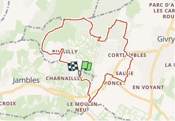

Length
10.2 km

Max alt
444 m

Uphill gradient
260 m
Km-Effort
13.7 km

Min alt
233 m

Downhill gradient
259 m
Boucle
Yes
Creation date :
2019-01-15 20:29:58.895
Updated on :
2019-01-15 20:29:58.895
--
Difficulty : Unknown

FREE GPS app for hiking
 SityTrail
IGN / Geographical institutes
SityTrail Plus
The world is yours!
About
Trail Walking of 10.2 km to be discovered at Bourgogne-Franche-Comté, Saône-et-Loire, Jambles. This trail is proposed by LUCIE2016.
Positioning
Country:
France
Region :
Bourgogne-Franche-Comté
Department/Province :
Saône-et-Loire
Municipality :
Jambles
Location:
Unknown
Start:(Dec)
Start:(UTM)
630770 ; 5181453 (31T) N.
Comments