


D_Abbaye de Chaalis_ 11.1 km

GOELERANDO2
User
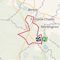

Length
11.1 km

Max alt
101 m

Uphill gradient
100 m
Km-Effort
12.4 km

Min alt
65 m

Downhill gradient
105 m
Boucle
Yes
Creation date :
2019-01-15 20:39:32.481
Updated on :
2019-01-15 20:39:32.481
2h44
Difficulty : Medium

FREE GPS app for hiking
 SityTrail
IGN / Geographical institutes
SityTrail Plus
The world is yours!
About
Trail Walking of 11.1 km to be discovered at Hauts-de-France, Oise, Fontaine-Chaalis. This trail is proposed by GOELERANDO2.
Description
Départ et parking de L'Abbaye de Chaalis (60)
Positioning
Country:
France
Region :
Hauts-de-France
Department/Province :
Oise
Municipality :
Fontaine-Chaalis
Location:
Unknown
Start:(Dec)
Start:(UTM)
476831 ; 5443898 (31U) N.
Comments
génial