


Joug le Comte Montrognon

avdem
User
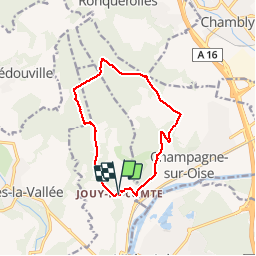

Length
11.1 km

Max alt
146 m

Uphill gradient
191 m
Km-Effort
13.7 km

Min alt
34 m

Downhill gradient
193 m
Boucle
Yes
Creation date :
2019-01-15 20:40:33.537
Updated on :
2019-01-15 20:40:33.537
3h00
Difficulty : Unknown

FREE GPS app for hiking
 SityTrail
IGN / Geographical institutes
SityTrail Plus
The world is yours!
About
Trail Other activity of 11.1 km to be discovered at Ile-de-France, Val-d'Oise, Parmain. This trail is proposed by avdem.
Description
11.1
Positioning
Country:
France
Region :
Ile-de-France
Department/Province :
Val-d'Oise
Municipality :
Parmain
Location:
Unknown
Start:(Dec)
Start:(UTM)
442133 ; 5441959 (31U) N.
Comments