


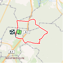
D_Thiers sur Thève EST _ 10.3 km

GOELERANDO2
User

Length
10.3 km

Max alt
115 m

Uphill gradient
105 m
Km-Effort
11.7 km

Min alt
63 m

Downhill gradient
108 m
Boucle
Yes
Creation date :
2019-01-15 20:40:53.258
Updated on :
2019-01-15 20:40:53.258
1h13
Difficulty : Unknown

FREE GPS app for hiking
 SityTrail
IGN / Geographical institutes
SityTrail Plus
The world is yours!
About
Trail Walking of 10.3 km to be discovered at Hauts-de-France, Oise, Thiers-sur-Thève. This trail is proposed by GOELERANDO2.
Description
Départ et parking du stade de Thiers sur Thève (60)
Positioning
Country:
France
Region :
Hauts-de-France
Department/Province :
Oise
Municipality :
Thiers-sur-Thève
Location:
Unknown
Start:(Dec)
Start:(UTM)
469579 ; 5445097 (31U) N.
Comments
hhhhh