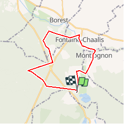
V_Abbaye de Chaalis_12 km

GOELERANDO2
User

Length
12 km

Max alt
99 m

Uphill gradient
106 m
Km-Effort
13.4 km

Min alt
63 m

Downhill gradient
107 m
Boucle
Yes
Creation date :
2019-01-15 20:41:03.164
Updated on :
2019-01-15 20:41:03.164
2h58
Difficulty : Unknown

FREE GPS app for hiking
 SityTrail
IGN / Geographical institutes
SityTrail Plus
The world is yours!
About
Trail Walking of 12 km to be discovered at Hauts-de-France, Oise, Fontaine-Chaalis. This trail is proposed by GOELERANDO2.
Description
Parking et départ Abbaye de Chaalis (60)
Positioning
Country:
France
Region :
Hauts-de-France
Department/Province :
Oise
Municipality :
Fontaine-Chaalis
Location:
Unknown
Start:(Dec)
Start:(UTM)
476817 ; 5443834 (31U) N.
Comments