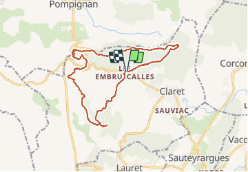
LL34 Reculée de Claret

alainandrejoly
User

Length
17.1 km

Max alt
414 m

Uphill gradient
372 m
Km-Effort
22 km

Min alt
173 m

Downhill gradient
373 m
Boucle
Yes
Creation date :
2019-01-15 20:51:25.785
Updated on :
2019-01-15 20:51:25.785
5h30
Difficulty : Medium

FREE GPS app for hiking
 SityTrail
IGN / Geographical institutes
SityTrail Plus
The world is yours!
About
Trail Walking of 17.1 km to be discovered at Occitania, Hérault, Claret. This trail is proposed by alainandrejoly.
Description
2019-01-14
Positioning
Country:
France
Region :
Occitania
Department/Province :
Hérault
Municipality :
Claret
Location:
Unknown
Start:(Dec)
Start:(UTM)
570954 ; 4857722 (31T) N.
Comments