


Circuit des vignes Verneuil

velofox
User
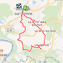

Length
7.5 km

Max alt
320 m

Uphill gradient
182 m
Km-Effort
9.9 km

Min alt
217 m

Downhill gradient
174 m
Boucle
Yes
Creation date :
2019-05-06 10:03:50.823
Updated on :
2019-05-06 10:03:50.823
2h04
Difficulty : Unknown

FREE GPS app for hiking
 SityTrail
IGN / Geographical institutes
SityTrail Plus
The world is yours!
About
Trail Walking of 7.5 km to be discovered at New Aquitaine, Haute-Vienne, Verneuil-sur-Vienne. This trail is proposed by velofox.
Positioning
Country:
France
Region :
New Aquitaine
Department/Province :
Haute-Vienne
Municipality :
Verneuil-sur-Vienne
Location:
Unknown
Start:(Dec)
Start:(UTM)
354562 ; 5078873 (31T) N.
Comments