


chanter merle les grognant

raygautier
User
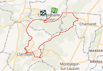

Length
22 km

Max alt
304 m

Uphill gradient
464 m
Km-Effort
28 km

Min alt
135 m

Downhill gradient
442 m
Boucle
No
Creation date :
2019-05-06 10:31:53.965
Updated on :
2023-02-10 20:33:25.822
6h56
Difficulty : Difficult

FREE GPS app for hiking
 SityTrail
IGN / Geographical institutes
SityTrail Plus
The world is yours!
About
Trail Walking of 22 km to be discovered at Auvergne-Rhône-Alpes, Drôme, Chantemerle-lès-Grignan. This trail is proposed by raygautier.
Positioning
Country:
France
Region :
Auvergne-Rhône-Alpes
Department/Province :
Drôme
Municipality :
Chantemerle-lès-Grignan
Location:
Unknown
Start:(Dec)
Start:(UTM)
646277 ; 4918294 (31T) N.
Comments