


2015-01-28T23:02:25Z

luccho
User
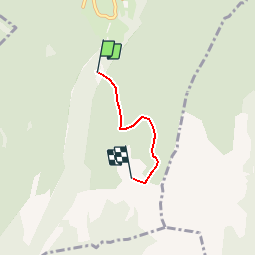

Length
2.5 km

Max alt
1749 m

Uphill gradient
608 m
Km-Effort
8.6 km

Min alt
1130 m

Downhill gradient
6 m
Boucle
No
Creation date :
2019-04-30 11:56:27.528
Updated on :
2019-04-30 11:56:27.528
--
Difficulty : Unknown

FREE GPS app for hiking
 SityTrail
IGN / Geographical institutes
SityTrail Plus
The world is yours!
About
Trail Other activity of 2.5 km to be discovered at Auvergne-Rhône-Alpes, Isère, Saint-Christophe-sur-Guiers. This trail is proposed by luccho.
Positioning
Country:
France
Region :
Auvergne-Rhône-Alpes
Department/Province :
Isère
Municipality :
Saint-Christophe-sur-Guiers
Location:
Unknown
Start:(Dec)
Start:(UTM)
719077 ; 5031286 (31T) N.
Comments