Trail Walking Théméricourt - L'Aubette - Parc du Véxin - Photo

L'Aubette - Parc du Véxin

 tracegps
tracegps

User

© OpenStreetMap contributors
Length
Length
25 km
Max alt
Max alt
122 m
Uphill gradient
Uphill gradient
338 m
Km-Effort
Km-Effort  
29 km
Min alt
Min alt
42 m
Downhill gradient
Downhill gradient
333 m
Boucle
Boucle
Yes
Creation date :
2014-12-10 00:00:00.0
Updated on :
2014-12-10 00:00:00.0

(0 Reviews)

Walking
Walking
5h00
Difficulty : Difficult

Scan this QR Code to open this trail in the SityTrail application

FREE GPS app for hiking

Logo SityTrail SityTrail

IGN / Geographical institutes

Download SityTrail from the App Store Download SityTrail from Google Play

Logo SityTrail SityTrail World

The world is yours!

Download SityTrail from the App Store Download SityTrail from Google Play Download SityTrail on Huawei AppGallery

About

Trail Walking of 25 km to be discovered at Ile-de-France, Val-d'Oise, Théméricourt. This trail is proposed by tracegps.

Description

Circuit proposé par le Comité Départemental de Randonnée des Hauts de Seine. Caractéristiques : Circuit M4 du parc du Vexin, boue lourde par temps de pluie, circuit d’été. Descriptif : Théméricourt Château maison du Parc, bois du Val, la Croix Rouge, Longuesse .... GR1, Sagy, Gondécourt, Villette (14 km) … PR, Bois des Sapins, Saillancourt, Sagy, le Grand Mesnil, le Petit Mesnil, Longuesse … GR1, Vigny, le Ragny, Théméricourt. Des sentiers ont pu être modifiés depuis la dernière validation et les itinéraires proposés n’engagent pas la responsabilité du Comité. Signalez-nous les modifications rencontrées pour mise à jour de la randothèque.

Elevation profile

Photos

Positioning

Country:
France
Region :
Ile-de-France
Department/Province :
Val-d'Oise
Municipality :
Théméricourt
Location:
Unknown
Start:(UTM)
419307 ; 5437583 (31U) N.

Trails nearby

Trail Nordic walking Frémainville - Forêt de Galluis - Photo
Nordic walking
Fky78

Nordic walking

Easy
(1)
Frémainville, Ile-de-France, Val-d'Oise, France
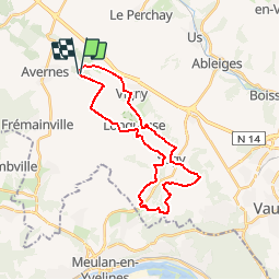
6 km | 7.3 km-effort
1h 20min
Yes
Trail Walking Frémainville - Fremainville marche 6km - Photo
Walking
unirega

Walking

Medium
(2)
Frémainville, Ile-de-France, Val-d'Oise, France
5.8 km | 7.9 km-effort
1h 20min
No
Trail Walking Théméricourt - Théméricourt - La vallée de l''Aubette - Photo
Walking
marcel.F

Walking

Easy
(1)
Théméricourt, Ile-de-France, Val-d'Oise, France
10.4 km | 12.3 km-effort
2h 42min
Yes
Trail Walking Le Perchay - le perchay etang de valliere santeuil - Photo
Walking
jeang95

Walking

Very easy
(2)
Le Perchay, Ile-de-France, Val-d'Oise, France
6.9 km | 8.1 km-effort
1h 34min
Yes
Trail Walking Wy-dit-Joli-Village - Wy dit joli village-Guiry-Gadancourt (boucle) - Photo
Walking
mictar78

Walking

Easy
(1)
Wy-dit-Joli-Village, Ile-de-France, Val-d'Oise, France
11.1 km | 13.3 km-effort
2h 32min
Yes
Trail Walking Commeny - Commeny - L'eau et le pain - Photo
Walking
marcel.F

Walking

Easy
(4)
Commeny, Ile-de-France, Val-d'Oise, France
13.2 km | 15.1 km-effort
3h 18min
Yes
Trail Walking Vigny - Ligny - Photo
Walking
avdem

Walking

Easy
Vigny, Ile-de-France, Val-d'Oise, France
9.2 km | 11 km-effort
2h 8min
Yes
Trail Walking Commeny - Kimrny - Photo
Walking
avdem

Walking

Very easy
Commeny, Ile-de-France, Val-d'Oise, France
13.8 km | 15.7 km-effort
3h 21min
Yes
Trail On foot Santeuil - Le tour du Grand Paris via le GR1 - Etape 4  - Photo
On foot
chessyca

On foot

Difficult
Santeuil, Ile-de-France, Val-d'Oise, France
34 km | 39 km-effort
8h 58min
No


Close
My subscriptions