


La Madone d'Utelle

franquen
User

Length
10.5 km

Max alt
1188 m

Uphill gradient
729 m
Km-Effort
20 km

Min alt
612 m

Downhill gradient
731 m
Boucle
Yes
Creation date :
2019-05-06 10:48:07.092
Updated on :
2019-05-06 10:48:07.092
4h02
Difficulty : Medium

FREE GPS app for hiking
 SityTrail
IGN / Geographical institutes
SityTrail Plus
The world is yours!
About
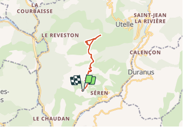
Trail Walking of 10.5 km to be discovered at Provence-Alpes-Côte d'Azur, Maritime Alps, Utelle. This trail is proposed by franquen.
Description
depart de la Villette , sentier facile mais caillouteux, batons recommandés pour la descente.
Beau point de vue à la Madone sur 360°
Positioning
Country:
France
Region :
Provence-Alpes-Côte d'Azur
Department/Province :
Maritime Alps
Municipality :
Utelle
Location:
Unknown
Start:(Dec)
Start:(UTM)
357010 ; 4860551 (32T) N.
Comments