


3 mai 2019 jour 3

dudu85
User

Length
28 km

Max alt
21 m

Uphill gradient
185 m
Km-Effort
31 km

Min alt
0 m

Downhill gradient
185 m
Boucle
No
Creation date :
2019-01-29 17:23:36.021
Updated on :
2019-04-29 04:39:33.609
7h25
Difficulty : Unknown

FREE GPS app for hiking
 SityTrail
IGN / Geographical institutes
SityTrail Plus
The world is yours!
About
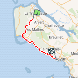
Trail Walking of 28 km to be discovered at New Aquitaine, Charente-Maritime, Arvert. This trail is proposed by dudu85.
Description
Départ " Lieu-Dit Dirée" commune d'Alvert direction Royan en passant par La Palmyre.
Distance cumulée 75,200km
Positioning
Country:
France
Region :
New Aquitaine
Department/Province :
Charente-Maritime
Municipality :
Arvert
Location:
Unknown
Start:(Dec)
Start:(UTM)
643642 ; 5067822 (30T) N.
Comments