


4 mai 2019 jour 4

dudu85
User

Length
37 km

Max alt
24 m

Uphill gradient
211 m
Km-Effort
40 km

Min alt
0 m

Downhill gradient
207 m
Boucle
No
Creation date :
2019-01-29 17:23:35.783
Updated on :
2019-04-29 04:42:00.406
7h21
Difficulty : Unknown

FREE GPS app for hiking
 SityTrail
IGN / Geographical institutes
SityTrail Plus
The world is yours!
About
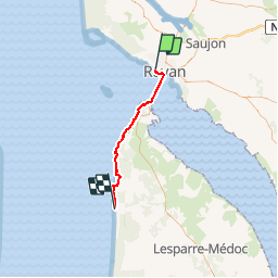
Trail Walking of 37 km to be discovered at New Aquitaine, Charente-Maritime, Royan. This trail is proposed by dudu85.
Description
Départ Royan direction Montalivet en prenant le bac pour La Pointe de Grave.
Distance cumulée 106,5km
Positioning
Country:
France
Region :
New Aquitaine
Department/Province :
Charente-Maritime
Municipality :
Royan
Location:
Unknown
Start:(Dec)
Start:(UTM)
651940 ; 5054481 (30T) N.
Comments