


Fontainebleau au sud 12.3 km

GOELERANDO2
User
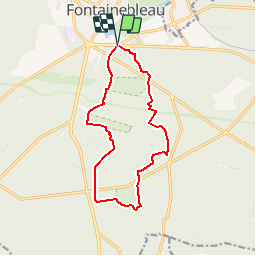

Length
12.3 km

Max alt
138 m

Uphill gradient
223 m
Km-Effort
15.2 km

Min alt
80 m

Downhill gradient
222 m
Boucle
Yes
Creation date :
2019-05-06 11:02:57.266
Updated on :
2019-05-06 11:02:57.266
3h18
Difficulty : Medium

FREE GPS app for hiking
 SityTrail
IGN / Geographical institutes
SityTrail Plus
The world is yours!
About
Trail Walking of 12.3 km to be discovered at Ile-de-France, Seine-et-Marne, Fontainebleau. This trail is proposed by GOELERANDO2.
Description
Parking et départ de la maison Forestière de Maintenon au sud du château.
Positioning
Country:
France
Region :
Ile-de-France
Department/Province :
Seine-et-Marne
Municipality :
Fontainebleau
Location:
Unknown
Start:(Dec)
Start:(UTM)
477969 ; 5360402 (31U) N.
Comments