


8482008-NOCTURNE LIEVIN

dehemjacques
User
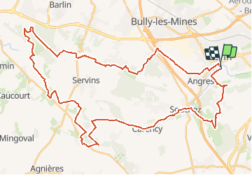

Length
51 km

Max alt
195 m

Uphill gradient
691 m
Km-Effort
60 km

Min alt
40 m

Downhill gradient
683 m
Boucle
No
Creation date :
2019-02-20 20:55:39.647
Updated on :
2019-02-20 20:55:39.647
--
Difficulty : Unknown

FREE GPS app for hiking
 SityTrail
IGN / Geographical institutes
SityTrail Plus
The world is yours!
About
Trail Other activity of 51 km to be discovered at Hauts-de-France, Pas-de-Calais, Liévin. This trail is proposed by dehemjacques.


Positioning
Country:
France
Region :
Hauts-de-France
Department/Province :
Pas-de-Calais
Municipality :
Liévin
Location:
Unknown
Start:(Dec)
Start:(UTM)
483985 ; 5585118 (31U) N.
Comments