


modave pont de bonne

ochelen
User
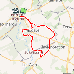

Length
13.3 km

Max alt
249 m

Uphill gradient
195 m
Km-Effort
15.9 km

Min alt
184 m

Downhill gradient
192 m
Boucle
Yes
Creation date :
2019-05-06 11:41:36.023
Updated on :
2019-05-06 11:41:36.023
2h49
Difficulty : Easy

FREE GPS app for hiking
 SityTrail
IGN / Geographical institutes
SityTrail Plus
The world is yours!
About
Trail Walking of 13.3 km to be discovered at Wallonia, Liège, Modave. This trail is proposed by ochelen.
Description
Ravel et boid
Positioning
Country:
Belgium
Region :
Wallonia
Department/Province :
Liège
Municipality :
Modave
Location:
Modave
Start:(Dec)
Start:(UTM)
662319 ; 5591314 (31U) N.
Comments