


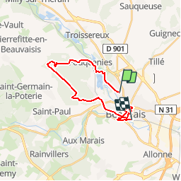
DES BOIS DU BEAUVAISIS AU BEAUVAIS MEDIEVAL

NUITEVEN
User

Length
20 km

Max alt
159 m

Uphill gradient
251 m
Km-Effort
24 km

Min alt
63 m

Downhill gradient
259 m
Boucle
No
Creation date :
2019-05-06 11:43:41.768
Updated on :
2019-05-12 10:35:41.084
5h29
Difficulty : Unknown

FREE GPS app for hiking
 SityTrail
IGN / Geographical institutes
SityTrail Plus
The world is yours!
About
Trail Walking of 20 km to be discovered at Hauts-de-France, Oise, Beauvais. This trail is proposed by NUITEVEN.
Positioning
Country:
France
Region :
Hauts-de-France
Department/Province :
Oise
Municipality :
Beauvais
Location:
Unknown
Start:(Dec)
Start:(UTM)
433050 ; 5477247 (31U) N.
Comments