


Tachenires Contranhé Arfaye

libinsport
User
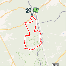

Length
9.9 km

Max alt
491 m

Uphill gradient
260 m
Km-Effort
13.3 km

Min alt
374 m

Downhill gradient
254 m
Boucle
Yes
Creation date :
2019-05-06 11:45:37.244
Updated on :
2019-05-06 11:45:37.244
2h50
Difficulty : Unknown

FREE GPS app for hiking
 SityTrail
IGN / Geographical institutes
SityTrail Plus
The world is yours!
About
Trail Walking of 9.9 km to be discovered at Wallonia, Luxembourg, Libin. This trail is proposed by libinsport.
Positioning
Country:
Belgium
Region :
Wallonia
Department/Province :
Luxembourg
Municipality :
Libin
Location:
Libin
Start:(Dec)
Start:(UTM)
666007 ; 5539860 (31U) N.
Comments