


le greseau chemin des chapelles

losjo
User
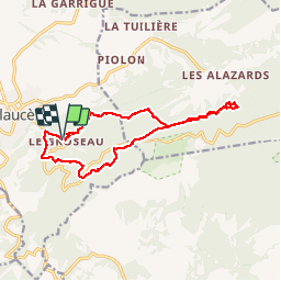

Length
14.7 km

Max alt
780 m

Uphill gradient
621 m
Km-Effort
23 km

Min alt
377 m

Downhill gradient
619 m
Boucle
Yes
Creation date :
2019-05-06 14:32:51.513
Updated on :
2019-05-06 14:32:51.513
4h37
Difficulty : Medium

FREE GPS app for hiking
 SityTrail
IGN / Geographical institutes
SityTrail Plus
The world is yours!
About
Trail Walking of 14.7 km to be discovered at Provence-Alpes-Côte d'Azur, Vaucluse, Malaucène. This trail is proposed by losjo.
Positioning
Country:
France
Region :
Provence-Alpes-Côte d'Azur
Department/Province :
Vaucluse
Municipality :
Malaucène
Location:
Unknown
Start:(Dec)
Start:(UTM)
671686 ; 4892707 (31T) N.
Comments