


Chagny 12/2 André

yakout
User
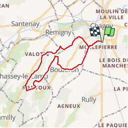

Length
13.1 km

Max alt
377 m

Uphill gradient
336 m
Km-Effort
17.6 km

Min alt
218 m

Downhill gradient
337 m
Boucle
Yes
Creation date :
2019-05-06 14:34:49.898
Updated on :
2019-05-06 14:34:49.898
3h44
Difficulty : Medium

FREE GPS app for hiking
 SityTrail
IGN / Geographical institutes
SityTrail Plus
The world is yours!
About
Trail Walking of 13.1 km to be discovered at Bourgogne-Franche-Comté, Saône-et-Loire, Chagny. This trail is proposed by yakout.
Positioning
Country:
France
Region :
Bourgogne-Franche-Comté
Department/Province :
Saône-et-Loire
Municipality :
Chagny
Location:
Unknown
Start:(Dec)
Start:(UTM)
633489 ; 5195804 (31T) N.
Comments