


mery Merkel frzpullon

avdem
User
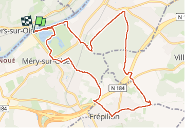

Length
11.6 km

Max alt
107 m

Uphill gradient
153 m
Km-Effort
13.6 km

Min alt
23 m

Downhill gradient
149 m
Boucle
Yes
Creation date :
2019-05-06 14:42:07.14
Updated on :
2019-05-06 14:42:07.14
2h37
Difficulty : Unknown

FREE GPS app for hiking
 SityTrail
IGN / Geographical institutes
SityTrail Plus
The world is yours!
About
Trail Other activity of 11.6 km to be discovered at Ile-de-France, Val-d'Oise, Méry-sur-Oise. This trail is proposed by avdem.
Positioning
Country:
France
Region :
Ile-de-France
Department/Province :
Val-d'Oise
Municipality :
Méry-sur-Oise
Location:
Unknown
Start:(Dec)
Start:(UTM)
440077 ; 5435525 (31U) N.
Comments