


DOURDAN - RAMBOUILLET

NUITEVEN
User
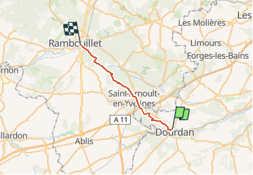

Length
22 km

Max alt
180 m

Uphill gradient
242 m
Km-Effort
25 km

Min alt
94 m

Downhill gradient
197 m
Boucle
No
Creation date :
2019-05-06 14:52:54.392
Updated on :
2020-01-18 16:52:08.14
5h31
Difficulty : Easy

FREE GPS app for hiking
 SityTrail
IGN / Geographical institutes
SityTrail Plus
The world is yours!
About
Trail Walking of 22 km to be discovered at Ile-de-France, Essonne, Dourdan. This trail is proposed by NUITEVEN.
Positioning
Country:
France
Region :
Ile-de-France
Department/Province :
Essonne
Municipality :
Dourdan
Location:
Unknown
Start:(Dec)
Start:(UTM)
426892 ; 5376074 (31U) N.
Comments