


Mayres-Savel

maupassant38
User
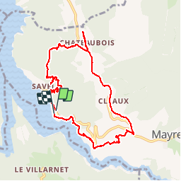

Length
9.3 km

Max alt
738 m

Uphill gradient
299 m
Km-Effort
13.3 km

Min alt
488 m

Downhill gradient
308 m
Boucle
Yes
Creation date :
2019-02-22 22:30:25.635
Updated on :
2019-02-22 22:30:25.65
2h13
Difficulty : Easy

FREE GPS app for hiking
 SityTrail
IGN / Geographical institutes
SityTrail Plus
The world is yours!
About
Trail Walking of 9.3 km to be discovered at Auvergne-Rhône-Alpes, Isère, Mayres-Savel. This trail is proposed by maupassant38.
Positioning
Country:
France
Region :
Auvergne-Rhône-Alpes
Department/Province :
Isère
Municipality :
Mayres-Savel
Location:
Unknown
Start:(Dec)
Start:(UTM)
712554 ; 4972985 (31T) N.
Comments