


ST ISMIER LES BORNES

RD78-38
User
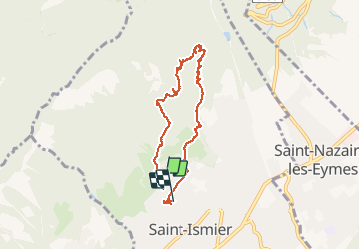

Length
7.4 km

Max alt
761 m

Uphill gradient
341 m
Km-Effort
12 km

Min alt
419 m

Downhill gradient
369 m
Boucle
No
Creation date :
2019-02-17 17:33:05.679
Updated on :
2020-07-11 00:21:14.313
3h23
Difficulty : Easy

FREE GPS app for hiking
 SityTrail
IGN / Geographical institutes
SityTrail Plus
The world is yours!
About
Trail Other activity of 7.4 km to be discovered at Auvergne-Rhône-Alpes, Isère, Saint-Ismier. This trail is proposed by RD78-38.
Description
Parcours sympathique et facile. Descente un peu glissante par endroits
Positioning
Country:
France
Region :
Auvergne-Rhône-Alpes
Department/Province :
Isère
Municipality :
Saint-Ismier
Location:
Unknown
Start:(Dec)
Start:(UTM)
721403 ; 5014933 (31T) N.
Comments