


CARANCA ALLER

UDGI54
User
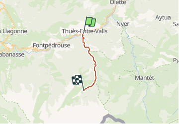

Length
8.7 km

Max alt
1838 m

Uphill gradient
1085 m
Km-Effort
19.9 km

Min alt
856 m

Downhill gradient
117 m
Boucle
No
Creation date :
2019-05-06 15:03:22.003
Updated on :
2019-05-06 15:03:22.003
--
Difficulty : Unknown

FREE GPS app for hiking
 SityTrail
IGN / Geographical institutes
SityTrail Plus
The world is yours!
About
Trail Walking of 8.7 km to be discovered at Occitania, Pyrénées-Orientales, Thuès-Entre-Valls. This trail is proposed by UDGI54.


Positioning
Country:
France
Region :
Occitania
Department/Province :
Pyrénées-Orientales
Municipality :
Thuès-Entre-Valls
Location:
Unknown
Start:(Dec)
Start:(UTM)
436176 ; 4708168 (31T) N.
Comments