


le puy de pilleyre

jeanic63
User

Length
9.1 km

Max alt
524 m

Uphill gradient
243 m
Km-Effort
12.4 km

Min alt
346 m

Downhill gradient
239 m
Boucle
Yes
Creation date :
2019-05-06 15:20:51.786
Updated on :
2020-02-13 17:57:17.159
2h17
Difficulty : Unknown

FREE GPS app for hiking
 SityTrail
IGN / Geographical institutes
SityTrail Plus
The world is yours!
About
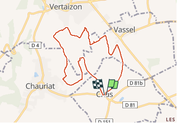
Trail Other activity of 9.1 km to be discovered at Auvergne-Rhône-Alpes, Puy-de-Dôme, Chas. This trail is proposed by jeanic63.
Description
départ CHAS monument aux morts vers la mairie puy de dome
Positioning
Country:
France
Region :
Auvergne-Rhône-Alpes
Department/Province :
Puy-de-Dôme
Municipality :
Chas
Location:
Unknown
Start:(Dec)
Start:(UTM)
523520 ; 5066183 (31T) N.
Comments