


25 FEVRIER 2019

FLOCON
User
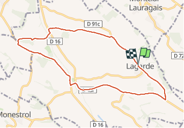

Length
10.3 km

Max alt
296 m

Uphill gradient
189 m
Km-Effort
12.8 km

Min alt
190 m

Downhill gradient
189 m
Boucle
Yes
Creation date :
2019-05-06 15:40:25.421
Updated on :
2019-05-06 15:40:25.421
2h36
Difficulty : Medium

FREE GPS app for hiking
 SityTrail
IGN / Geographical institutes
SityTrail Plus
The world is yours!
About
Trail Walking of 10.3 km to be discovered at Occitania, Haute-Garonne, Lagarde. This trail is proposed by FLOCON.
Description
LAGARDR
Positioning
Country:
France
Region :
Occitania
Department/Province :
Haute-Garonne
Municipality :
Lagarde
Location:
Unknown
Start:(Dec)
Start:(UTM)
395641 ; 4800076 (31T) N.
Comments