


rando , Alexis et Izzie

fredodlageo
User
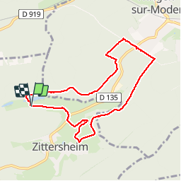

Length
7.9 km

Max alt
278 m

Uphill gradient
128 m
Km-Effort
9.6 km

Min alt
216 m

Downhill gradient
120 m
Boucle
Yes
Creation date :
2019-05-06 15:42:14.163
Updated on :
2019-05-06 15:42:14.163
2h01
Difficulty : Very easy

FREE GPS app for hiking
 SityTrail
IGN / Geographical institutes
SityTrail Plus
The world is yours!
About
Trail Walking of 7.9 km to be discovered at Grand Est, Bas-Rhin, Zittersheim. This trail is proposed by fredodlageo.
Photos


Positioning
Country:
France
Region :
Grand Est
Department/Province :
Bas-Rhin
Municipality :
Zittersheim
Location:
Unknown
Start:(Dec)
Start:(UTM)
378398 ; 5418385 (32U) N.
Comments