


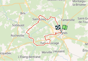
Variante Bocage Valognais Côté Ouest

tracegps
User


1h30
Difficulty : Medium

FREE GPS app for hiking
 SityTrail
IGN / Geographical institutes
SityTrail Plus
The world is yours!
About
Trail Cycle of 27 km to be discovered at Normandy, Manche, Valognes. This trail is proposed by tracegps.
Description
En partant de VALOGNES, ce circuit vous permet de découvrir la commune de YVETOT-BOCAGE, ensuite vous arrivez à NEGREVILLE et vous revenez vers la commune de SAINT-JOSEPH pour rejoindre le centre-ville de VALOGNES. Il s'agit d'une variante proposée pour le circuit du Bocage Valognais Côté Ouest.
Positioning
Comments