


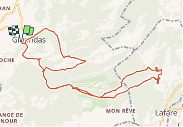
tour des dentelles clapis

losjo
User

Length
15.2 km

Max alt
468 m

Uphill gradient
702 m
Km-Effort
25 km

Min alt
199 m

Downhill gradient
703 m
Boucle
Yes
Creation date :
2019-05-06 16:34:52.992
Updated on :
2019-05-06 16:34:52.992
8h39
Difficulty : Very difficult

FREE GPS app for hiking
 SityTrail
IGN / Geographical institutes
SityTrail Plus
The world is yours!
About
Trail Walking of 15.2 km to be discovered at Provence-Alpes-Côte d'Azur, Vaucluse, Gigondas. This trail is proposed by losjo.
Positioning
Country:
France
Region :
Provence-Alpes-Côte d'Azur
Department/Province :
Vaucluse
Municipality :
Gigondas
Location:
Unknown
Start:(Dec)
Start:(UTM)
660127 ; 4891982 (31T) N.
Comments