


col du Berceau en boucle

PEBREJOSIANE
User
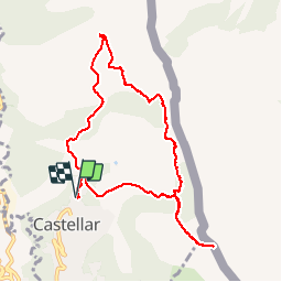

Length
10.1 km

Max alt
1096 m

Uphill gradient
793 m
Km-Effort
21 km

Min alt
347 m

Downhill gradient
795 m
Boucle
Yes
Creation date :
2019-05-06 16:59:01.893
Updated on :
2019-05-06 16:59:01.893
5h05
Difficulty : Unknown

FREE GPS app for hiking
 SityTrail
IGN / Geographical institutes
SityTrail Plus
The world is yours!
About
Trail Walking of 10.1 km to be discovered at Provence-Alpes-Côte d'Azur, Maritime Alps, Castellar. This trail is proposed by PEBREJOSIANE.
Description
départ et arrivée Cimetière de Castellar
Positioning
Country:
France
Region :
Provence-Alpes-Côte d'Azur
Department/Province :
Maritime Alps
Municipality :
Castellar
Location:
Unknown
Start:(Dec)
Start:(UTM)
379256 ; 4851572 (32T) N.
Comments